Press release 2013-06-10 at 12:28
Press release by the Ministry of Employment and the Economy, the Ministry of Agriculture and Forestry and the Finnish Environment Institute
 A new geographic classification about the distribution of urban and rural areas provides a more accurate picture than previous statistics of, among other things, the distribution of Finland's population in different areas. This unique division – from the European perspective – makes it possible, with the help of statistics based on geographical information, to outline development on an area level that is more accurate than a division based on municipal boundaries. Thus also regional differences are easier to take into account in planning and decision-making. More accurate information makes it possible to examine, in a more diverse manner, interaction between areas and anticipate the developments of different types of areas.
Due to the local government reform, the earlier classification based on administrative region divisions does not describe adequately the development of different types of areas. Especially, as the municipalities grow in size, the same municipality might include areas with urban characteristics and areas with rural characteristics.
"Measuring cities' population densities on a municipal level may result in, for example, that Tampere by its population density does not satisfy the city criteria defined by the EU", explains Ville Helminen, a researcher at the Finnish Environment Institute.
Seventy percent of Finns live in urban regions
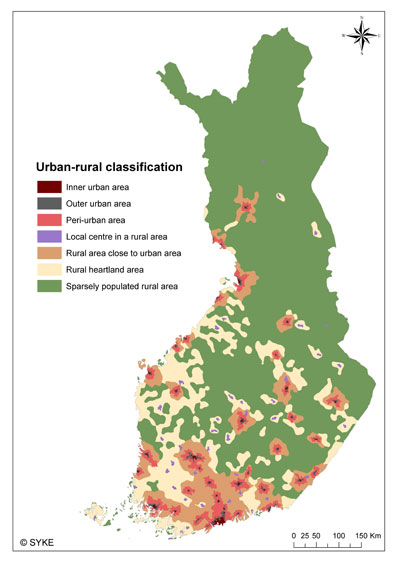
In the new classification, areas are divided into seven different classes. The classification reveals for example that 70 percent of Finland's population lives in urban regions. However, these areas cover only about five percent of the country's total area. Urban areas have now been defined more precisely: the population density of an urban area is 1,251 inhabitants per square kilometre, whereas in the earlier classification the density of urban municipalities was only 160 inhabitants per square kilometre.
Nearly 70 percent of Finland is sparsely populated rural area, but there are only 308,000 inhabitants, that is, 6% of the population. Approximately 400,000 Finns live in rural areas close to urban areas. These are areas with significant work-related commuting to cities and towns. The rest of nearly 40 percent of the 1.66 million rural inhabitants live in rural heartland areas. Rural heartland area is characterized by relatively intensive land use and diversified industry.
The population growth in Finland has concentrated in urban areas and areas neighbouring them. The redefined urban area has during 2000–2012 increased its population by 256,000, the peri-urban area by 78,700 and the rural areas close to urban areas by 20,000.
Diverse data on the background
The new urban-rural classification was realized with geographical information methods, and calculations have mainly taken place with a very accurate 250 x 250 metre grid. The source material included population, labour, work journey and building information as well as road network and land use data. Based on these, variables which describe quantity, density, efficiency, accessibility, intensity, diversity and direction were calculated.
"The classification is unique even on a European level, as the extensive base data allows completely new examinations and calculations to be made. Finnish data are of high quality, and the Finnish Environment Institute has developed, with a long term perspective, systems and methods with which to utilize geographical information", Ville Helminen explains. The main part of the classification was done at the Finnish Environment Institute and includes the accessibility calculations by the Department of Geography of the University of Oulu. The work was ordered by the Ministry of Employment and the Economy and the Ministry of Agriculture and Forestry.
The classification and a brochure are freely downloadable from the web in a geographic information systems format
The classification will be made public on Monday 10 June, starting at noon, and it’s publication can be seen live on the Internet:
Additional information
Ministerial Adviser Sirpa Karjalainen, Ministry of Agriculture and Forestry, firstname.lastname@mmm.fi,
tel. +358 (0)40 524 6112
Senior Officer Tarja Pyöriä, Ministry of Employment and the Economy, firstname.lastname@tem.fi,
tel. +358 (0)29 506 4918
Researcher Ville Helminen, Finnish Environment Institute SYKE, firstname.lastname@environment.fi,
tel. +358 (0)400 148 845
Photo for media