Use of earth observation for environmental monitoring and assessment
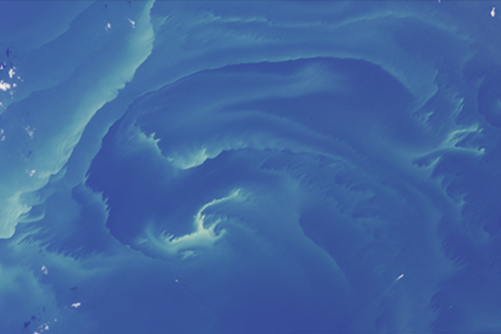
© Satellite image © USGS/NASA Landsat Program, SYKE
Since mid-1990s, SYKE has put a significant effort into developing earth observation methods that enable the production of sophisticated maps and time series from observation data. This work has taken place in a number of national and international projects, and it has evolved along with advancements in satellite sensors and interpretation techniques.
Sophisticated earth observation provides SYKE and other actors in the environment sector with relevant material for multiple purposes, such as evaluating and monitoring water quality, algal blooms, snow cover and land cover, with remarkably high spatial and temporal coverage.
The technical solutions and functions of observation methods, as well as the objects and parameters observed, have been carefully tailored to fulfil the needs of environmental authorities and stakeholders, including their reporting obligations. A web application STATUS serves the many needs of the authorities.
SYKE also recognizes the excellent opportunities given by earth observation to disseminate information and to raise environmental awareness among the public. Accordingly, the observation results have been made available to everybody through SYKE's TARKKA interface along with some thematic web applications. In addition, SYKE's cryosphere observation data is accessible through Copernicus Global Land Service.
The TARKKA web service contains satellite images and various earth observation and GIS materials which are updated daily, as well as long-term averages. The service has become very popular, and it is also regularly used by the press, particularly in summer when it offers daily satellite observations on water temperature and algal blooms, amongst others.
SYKE's experiences in developing TARKKA have contributed to the EU Copernicus Programme. The research and development carried out by SYKE in this field has also led to a more extensive and efficient monitoring of the Baltic Sea.
For more on the impacts:
New methods of biomonitoring
SYKE has pioneered in developing new methods for aquatic biomonitoring. These include DNA metabarcoding and image-based machine learning. Both are novel methods for routine biomonitoring, even though DNA metabarcoding is much used for other purposes. The aim has been to develop swifter and more accurate methods for monitoring benthic fauna, compared with traditional morphological identification of aquatic macroinvertebrates.
The development of the DNA metabarcoding method started in SYKE in 2013, and has since 2018 continued as an inter-Nordic project SCANDNAnet, which builds on the pilot work of SYKE. The project, now in its final stage, is starting to meet expectations: DNA metabarcoding identifies at least as many taxa as the classical morphology-based identification protocol, and yields a higher taxonomic resolution.
Image-based machine learning has likewise produced encouraging results in benthic taxa identification. SYKE has developed this method since 2007 in collaboration with two Finnish and one Danish university. Here SYKE brings understanding on the requirements, challenges and needs of biomonitoring, while the other partners develop machine learning and imaging techniques.
Both methods are expected to be in routine operational use within 3–5 years. The biggest remaining challenge relates to producing machine learning materials for this novel approach.
The outcome of these projects will influence method standardisation in the EU, as there is a great need to move on from traditional methods of biomonitoring, but validated or standardized new methods have been lacking. To advance the integration of molecular methods into routine aquatic monitoring SYKE actively pushed for establishing a dedicated group under European Committee for Standardization (CEN), which indeed took place in 2018 and where SYKE's experts now act as both the convener and secretary.
In SYKE, the next stage is to combine the two new methods and thereby achieve a (semi-) automatic biomonitoring method which not only identifies taxa but also yields other information on the state of benthic fauna. New projects have also started which aim at extending the methods to other sectors of biomonitoring, such as phyto- and zooplankton.
For more on the impacts:
Open data portal provides easy access to a range of users
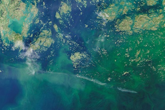
Copernicus Sentinel -data, SYKE (2020)
SYKE was one of the first governmental institutes in Finland to open its data. Our open data portal www.syke.fi/opendata provides extensive amounts of open environmental data in machine readable web services and interphases, downloadable data packages as well as environmental information systems and web map applications. The objective of the SYKE open data service is to provide easy access to environmental information for different user groups.
Since its opening in 2008, the portal has been continuously developed and the use rates of different services monitored. In 2019, the use rate of web map services reached nearly 120,000 requests (INSPIRE compliant web map services) in addition to almost 60,000 direct data downloads (spatial datasets). Web analytics show that syke.fi/opendata is among the most visited pages of the syke.fi service.
SYKE open data include a large range of information on water resources, surface and ground waters, the Baltic Sea, environmental load and distractions, valuable nature habitats and species, land cover and the built environment. In the near future SYKE plans to develop further and use advanced and effective methods to enable the faster utilization of information. These include as deep learning, complex optimization and artificial intelligence.
Private sector tops list of users of environmental data
According to a user survey in 2019, the SYKE Open Data portal is used widely in different sectors. The largest user group is the private sector, followed by local level administration, citizens as well as different governmental and research actors.
SYKE open data is widely utilized in for example planning and decision-making, consultancy assignments, the preparation and issuance of environmental permits, education and environmental monitoring. Enterprises make use of open data for product and service development and maintenance. SYKE open data services also provide citizens easy access to environmental information.
For more on the impacts:
MarineFinland.fi gathers sea data and knowledge from nine Finnish organizations and institutes
Spring 2020, SYKE launched a new web portal on marine data with other Finnish organizations and institutes.
“The Baltic Sea is an exceptional northern sea. We want to shed light on its many aspects. The marine information used to be difficult to find and use, as it was scattered in different places, with outdated user interfaces and hard to navigate websites. In this new site we have listened to our clients and emphasized usability and visuality,” says Project Coordinator Hanna Piepponen from the Finnish Environment Institute.
The Baltic Sea “Treasure Trove” consists of four parts:
- Marinefinland.fi offers marine information and research results in an easy and highly visual form for the public at large in Finnish, English and Swedish. There the visitor will learn about the changing natural environment of the Baltic, its societal links and marine research. It also recommends places to see for sightseers: lighthouses, historic wrecks, fortresses and the like.
- Seaguide.fi is a mobile service offering marine data and information on a map for boaters, trekkers, or anyone on the coast who might need it. It provides information on the weather and conditions at sea, restricted areas of various types, guest harbours, amounts of cyanobacteria, places worth a visit etc.
- Meriaineistot.fi allows the user to load Finnish marine research datasets on and viewing them in map form. Most of the marine geospatial and research data produced by research institutes is here openly available for use. Data can be retrieved from the databases of the research institutes and observed in map form. A tool of their own has been developed for marine area planning professionals. It is also a path to the services of Finnish research institutes and the download services of international marine data.
- Merihavainnot.fi is for downloading observations on the conditions out on the sea by SYKE and the Finnish Meteorological Institute. Observations include visibility depth of water, water level, thickness of ice cover, wave height, temperature of water surface and quality of water.
Working together for a common goal
SYKE coordinated this prime example of cooperation between a large number of partners from state administration: SYKE, the Geological Survey of Finland, the Finnish Meteorological Institute, the Natural Resources Institute of Finland, Metsähallitus, the Finnish Heritage Agency, Finnish Maritime Spatial Planning Coordination, Brahea Centre at the University of Turku and the Government of Åland. The consortium shared a common goal: to enhance appreciation of the Baltic and to make research results accessible to the common people.
It all started in 2015, when it occurred to SYKE that sea information and marine data were poorly available in Finland. Consequently, SYKE contacted other institutions that produced marine data.
A project to correct the state of affairs was launched in early 2017. In the course of the project, SYKE learned to adopt user experience as the basis of the new services that were developed.
Popularization of highly technical marine data for the benefit of different target groups wide apart followed. Thanks to the project and the portals it created, interaction between research institutes and the public at large has increased, awareness of different aspects of the Baltic Sea has improved, and cooperation between different research institutes has proven successful.
For more on the impacts
Monitoring of land cover
SYKE is very active in producing land use and land cover data. While this production represents the Finnish contribution to European wide CORINE/Copernicus programme, it also fulfils many other international, national and even local needs.
The history of SYKE's action in this field is long, and SYKE has also been one of the pioneers in Europe in applying novel methods, such as digital GIS data, automatic satellite image interpretation and, most recently, laser scanning. This has enabled the gathering and presentation of distinctly more detailed information than at the European level, ensuring wide applicability to different national purposes.
The SYKE method of producing Corine Land Cover rests on combining data from various sources, such as topographic data base, national forest inventory and the Building and dwelling register, and integrating them with land cover changes detected from multitemporal satellite images. The wide use of different data sources is possible because of the open data policy in Finland. Likewise, the land use and land cover datasets produced by SYKE are open to everybody. These databases are, indeed, one of the most downloaded materials in SYKE's open data portal.
Spatial information is used for multiple purposes, such as identifying habitats, monitoring changes in land use/cover and their impact on biodiversity and water quality, defining areas of flood risk, and assessing the sustainability of urban areas.
A growing demand for land cover data comes from climate change mitigation and adaptation, as here land use is one of the key sectors. The ambitious goal of Finland to reach carbon neutrality by 2035 means that all land use, including forestry, agriculture and building, must be assessed with respect to their impact on climate goals. This will clearly be a priority in the near future.
For more on the impacts