Hydraulic models and flood maps enable the identification of possible flood prone areas and assist in land use planning, rescue and communication. Hydraulic modelling also provides tools to simulate dam break and the transport of harmful substances in water systems.
Finnish Environment Institute SYKE has long experience in hydraulic modelling:
- Preparing river geometry
- Assembling the hydraulic model geometry from the river bathymetry and floodplain elevation data, e.g. based on a digital elevation model (DEM)
- ArcGIS or QGIS (open source) and HEC-RAS (available free of charge)
- Preparing the HEC-RAS model based on the geometry, 1D or 2D-modelling (dam break, river ice and lake regulation analyses also possible)
- Calibration of the model and simulation of the desired scenarios (e.g. different flood probabilities), including uncertainty analyses
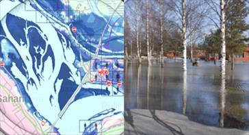
Flood model results and reality, photo Stig Hägglund
We offer the following services
- Structured support service for hydraulic modelling and for planning flood risk management
- Support service for different phases of hydraulic mapping (river geometry, modelling, calibration and simulation)
- Courses on hydraulic modelling and flood mapping as a whole or for individual phases